Planjeduik: a Zeeland dive planner for local and visiting divers
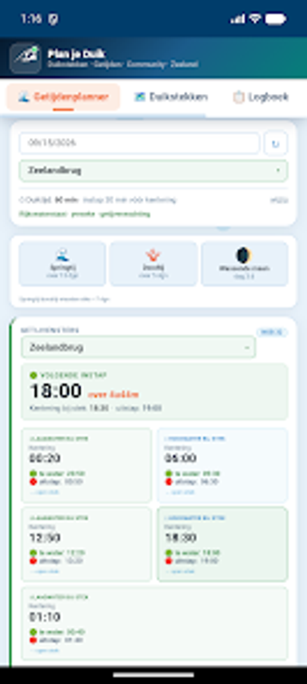
Plans dives using tide tables, current predictions, and a 77+ dive‑site database to pick safe windows and locations (tide planner, site filters, and flow data). De Witte Boulevard Persluchtstation built this lifestyle utility for Android and iOS users, bundling offline NOB emergency protocols, a digital logbook, and event listings. It suits Zeeland divers who want consolidated local data and community notices for trip-day decision making and on-site reference.
Delivers focused, location-specific planning for Zeeland dives
The app targets dives in the Oosterschelde, Grevelingenmeer, and Veerse Meer by presenting daily high/low tide times and water levels alongside current and flow information. Its 77+ dive‑site records show depth and accessibility, and distance-based sorting helps choose nearby sites. This arrangement supports choosing slack-water windows and matching site depth to planned dives without flipping between multiple sources.
Connects with local services and works on mobile devices
The developer built the tool to reach divers on Android and iOS, and it ties into local dive‑center expertise and event listings from De Witte Boulevard Persluchtstation. Site entries reference accessibility and distance so users can plan transport and logistics. Setup requires only a mobile device; no external hardware is listed as necessary to view tide or site information.
Provides safety resources that remain available offline
Emergency procedures come bundled as offline NOB protocols for the covered areas, letting divers access official steps without network access. The inclusion of an offline reference directly addresses urgent situations where connectivity fails, and the integrated digital logbook records dive dates, locations, depths, and notes for later review or debriefing.
Makes daily dive decisions simpler, with community context
Event tracking surfaces regional activities and local gatherings, which helps plan group dives or trainings. The app consolidates scattered planning data into one mobile view, so weekday or weekend planning fits into the routine of local recreational divers and visiting weekenders. Accuracy claims rest on published tide tables and local current data provided in the app.
To sum up, a practical planning aid for Zeeland divers
To sum up, the app is a sensible option for recreational and visiting divers who need centralized local data, offline emergency protocols, and a built‑in logbook. It is less suitable for divers who require global coverage beyond Zeeland or live telemetry from external sensors. For routine regional trips, it supports clearer go/no‑go choices and smoother day-of logistics.